Keywords:
Coastal vulnerability, InVEST model, Guangdong-Hong Kong-Macao Greater Bay AreaPublished
Issue
Section
License
Copyright (c) 2024 Jiayu Wang

This work is licensed under a Creative Commons Attribution 4.0 International License.
Abstract
Climate change and urbanization have caused coastal areas to be vulnerable to natural hazards. The article evaluates the coastal vulnerability of the Guangdong-Hong Kong-Macao Greater Bay Area (GHM-GBA) with the Integrated Valuation of Ecosystem Services and Trade-offs (InVEST) model and proposes targeted resilience planning strategies.
The Coastal Vulnerability Index (CVI) used in this study refers to measuring the vulnerability of coastal zones to sea level rise and storm surges based on paying full attention to the development of social dimensions in coastal areas (Ai et al., 2022; Caro et al., 2020; Hopper et al., 2016). The CVI includes an exposure index(EI), sensitivity index(SI), and adaptive capacity index(ACI): EI and SI refer to the propensity of coastal populations and properties to be adversely affected by natural disasters, while ACI refers to the ability of coastal communities to reduce the impact of natural disasters. Therefore, the study chose to measure CVI based on the Coastal Vulnerability model in the InVEST software to quantify the vulnerability of GHM-GBA 's coastal zones and identify urban areas susceptible to marine disasters in developing urban agglomerations.
In terms of data, EI data includes wave exposure, wind exposure, natural habitat and terrain data. The SI is characterized by population density, which comes from the GHM-GBA Statistical Yearbook. The ACI is characterized by the spatial pattern of transportation facilities and medical facilities, which can be obtained by writing Python code for Point of Interest. The specific analysis method is as follows: First, obtain vector graphics of coastlines, natural habitats, sea level change rates, sea level digital elevation models, and point data of storm wind speeds and surge levels. Secondly, the ArcGIS platform is used to visualize economic and social data, such as population density, GDP per capita index and distribution of hospitals. Finally, the coastal vulnerability assessment module imported into InVEST calculates a comprehensive vulnerability index to predict areas at high risk of inundation or erosion during storm surges (Figure 1).
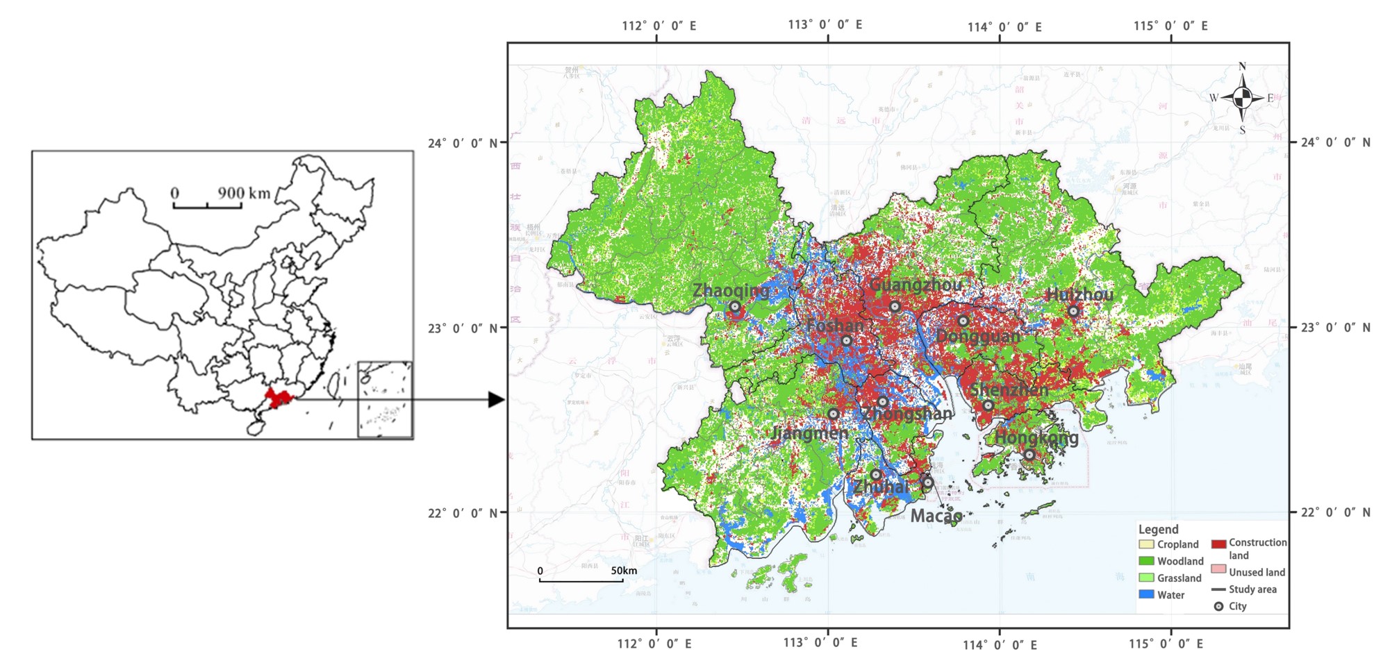
The GHM-GBA is a national strategy personally planned, deployed and promoted by General Secretary Xi Jinping. It is also a new practice that promotes the development of "one country, two systems". The GHM-GBA is an urban agglomeration composed of Guangzhou, Shenzhen and Zhuhai and Hong Kong and Macao’s two special administrative regions (Figure 2). It has a total land area of approximately 57,000 km2, a total population of approximately 86 million people in 2020, and a regional GDP of US$1,668.8 billion. Because coastal urban agglomerations gather high-density populations, industries, and facilities, when facing marine disasters, the degree of damage is much higher than that in inland areas. In 2018, climate disasters caused the total economic output of the GHM-GBA to reach 15.92 billion yuan. From 1949 to 2008, 125 storm surge disasters occurred in the GBA. The coastal areas of the GHM-GBA have become the "hardest hit areas" affected by floods and lowland inundation, posing a massive threat to infrastructure and the sustainable development of cities. Therefore, studying the assessment of GHM-GBA coastal vulnerability and discussing planning strategies to improve coastal resilience will be helpful for disaster prevention and ecological restoration of coastal urban agglomerations.
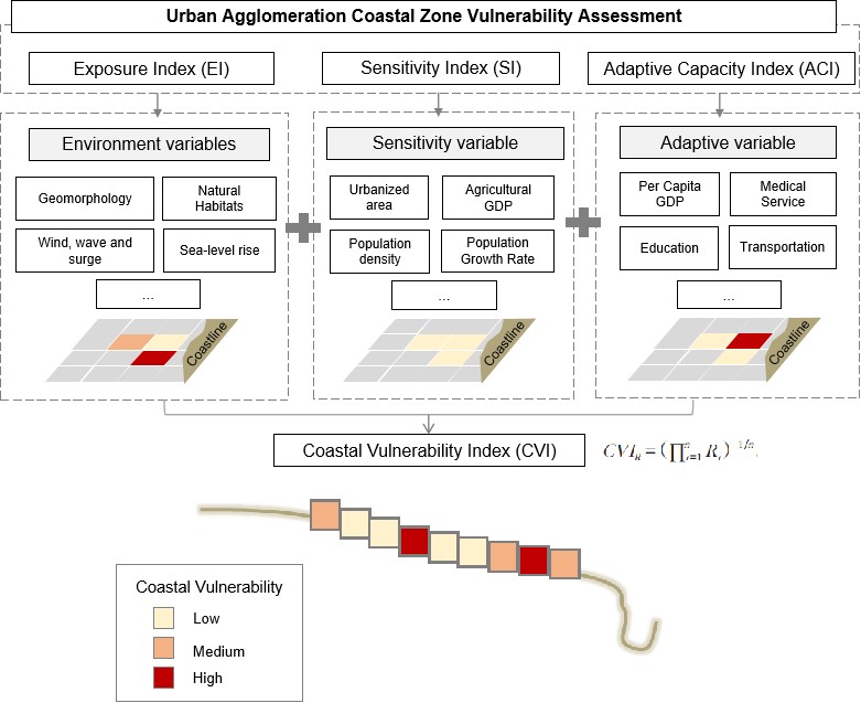
Figure 1 Research Framework
References
Ai, B. et al., (2022). Vulnerability analysis of coastal zone based on invest model in Jiaozhou Bay, China, Sustainability, 14(11), p. 6913. doi:10.3390/su14116913.
Hopper, T. and Meixler, M.S., (2016). Modeling coastal vulnerability through space and Time’, PLOS ONE, 11(10). doi:10.1371/journal.pone.0163495.
Caro, C. et al., (2020). Ecosystem Services as a resilience descriptor in habitat risk assessment using the invest model, Ecological Indicators, 115, p. 106426. doi:10.1016/j.ecolind.2020.106426.
